NOTES ON THE NOVEL: ISSUE 16
MAPS & ILLUSTRATIONS
This illustration, by Marcus Stone, appeared in the 1862 edition of Great Expectations. The original serial (1860-1) and the 1861 editions of the novel were not illustrated.

A Note on the Maps:
William Smith's 1815 Map and Delineation of the Strata of England and Wales with Part of Scotland gives a detailed account of the geography and geology of most of Great Britain. It consists of several large maps, each about 16x24 inches, mounted on canvas. These maps can be folded into smaller squares, and some of the seams -- where the map folds and the canvas shows through -- are visible on the sections of the maps reproduced here. The whole work consists of 16 large maps (a General Map of England, Wales and Scotland, and 15 regional maps), together with a Memoir discussing the geological study they illustrate. Detail from Map 12, in a reduced size, is reproduced below.
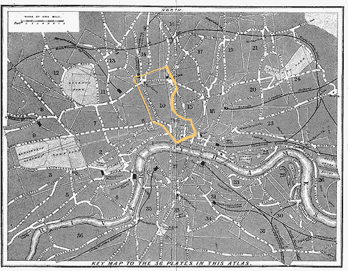
The city maps used to illustrate this issue are reproduced from Collins' Illustrated Atlas of London, published in 1854. Pip's London would have been that of the 1820s, and Dickens' London, at the time he was composing the novel, was that of 1860-1. Collins' maps thus represent a London that falls between the historical moment represented in the novel and the historical moment of the novel's composition.
Since the chapters in this issue (Chs. 51-53) take place in late 1829 (Meckier 160), the maps used here show a city that has undergone about 25 years of change since Pip's time. Nevertheless, they are very useful in tracking Pip's progress through the city; the reader should merely keep in mind that some of the landmarks would not have existed in the late 1820s. The most significant of these are the railway lines marked on the Key Map -- the railroad did not enter London until the late 1830s and early 1840s (Tallis's Illustrated London 186-7). The Key Map also shows a bridge that Pip would not have recognized -- the Hungerford Bridge between Waterloo and Westminster Bridges. And London Bridge was, in Pip's time, Old London Bridge -- a different structure, but built in essentially the same place. (New London Bridge would have begun construction a few yards from Old London Bridge when Pip was living in London, but would not have replaced the old bridge during his tenure [Meckier 162]. Given that both London Bridges would have been mapped in the same place, the difference between the bridges makes no difference to our reading of the map.) Any further discrepancies will be noted where appropriate.
History and features of Collins' Atlas (1854)
Collins' Atlas was created in response to the amplified tourist trade in London resulting from the Great Exhibition of 1851. Previous to the Atlas, maps tended to be very large and unwieldy, and though large city maps could be folded up and carried, Collins designed his maps with a specific view to portability (Dyos 10). The Atlas consists of one large map of the whole city of London (the Key Map), followed by 36 plates. The Key Map is drawn with numbered sections, and these sections are represented in detail by the plates (the numbers on the Key Map refer to the numbers of the plates). The chief drawback to the Atlas is that, although the Key Map keeps North at the top, the plates do not always observe this convention (Dyos 13). This disregard of the compass, however puzzling to someone attempting to navigate London in 1854, is in many respects an advantage for the modern reader: The detailed plates -- drawn to represent popular views of the city and/or popular routes through it -- give us a unique view of the sites of Pip's adventures in 19th century London. Any major discrepancies between the landmarks shown on the maps and those that Pip would have been acquainted with (given that the map was composed in 1854, about thirty years after Pip's tenure in London) will be indicated where appropriate.
A Note on the Illustrations
The engraved illustrations of London reproduced in this and other issue(s) were prepared as a result of the Great Exhibition of 1851. Tallis's Illustrated London (published in 1851-2, in two volumes) was created specifically to commemorate the Exhibition, and furnishes, not only a great many engravings of London scenes, but also a long history of, and commentary on, the sights of London and its environs. Since Tallis's Illustrated London was published almost 25 years after the events related in this issue (Chapters 51-53 take place in 1829 [Meckier 160]), some of the views commemorated in Tallis's would not have been available to Pip. Only those illustrations that show cityscapes and landmarks as they would have appeared to Pip in the 1820s have been included here.
A tour of chapters 51-53
The Key Map of Collins' Atlas, showing London as a whole, gives a useful overview of the city locations mentioned in this issue. The London locations described in Chapters 51-53 appear on the Key Map in area 10 (shown in detail on the corresponding Plate), and eastward down the river Thames, to Magwitch's hiding place and beyond. All of the maps reproduced here have been highlighted for convenience of reference and increased legibility.

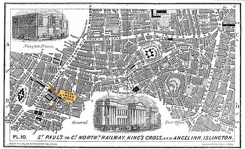
At the beginning of Chapter 51, Pip and Herbert walk together to "the corner of Giltspur Street, by Smithfield," where they part -- Pip destined for Jaggers' offices in Little Britain. Giltspur Street, Smithfield, and Little Britain are visible on Plate 10 of Collins' Atlas (below). Pip and Herbert have walked east from their lodgings in the Temple.

Note that Plate 10 of Collins' Atlas, composed in 1854, includes certain elements of London that would not have existed in 1829 (when Chapters 51-53 take place). The Great Northern Railway Terminus (mentioned in the caption) was not yet constructed; and the General Post Office (illustrated at the bottom center of the map), though completed in 1829, would not be open for several months (it opened in September) (Tallis's Illustrated London, vol. 1, 206).
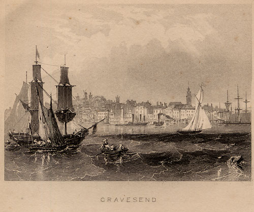
Pip, contemplating the escape route for Magwitch, "always proposed to [himself] to get [Magwitch] well down the river in the boat: certainly well beyond Gravesend" (Ch. 52). Gravesend is a town on the river Thames almost at the Mouth of the Thames (where the river meets the sea). Tallis's Illustrated London offers an engraving (below) of Gravesend which, incorporating the river, gives us a view of Pip's projected destination.

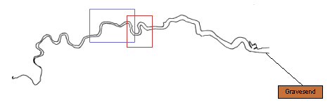
The map below shows Gravesend relative to London and Magwitch's hiding place.
EXTENDED MAP OF THE THAMES -- LONDON & ITS ENVIRONS
The blue box in the center of this map marks the area covered by the Key Map of Collins' Illustrated Atlas of London. The red box to the right of center marks the area -- "down the Pool there between Limehouse and Greenwich" (Ch. 45) -- where Magwitch is hidden.

ALLUSIONS
Land of the Arabian Nights: When Herbert dreams of "conducting Clara Barley to the land of the Arabian Nights" (Ch. 52), he means Egypt, for we find out later that Clarriker's has offices in Cairo. The Arabian Nights, or The One Thousand and One Nights is a collection of stories of diverse origin -- Indian, Persian, and Arabic (Oxford Companion 36-7) -- connected by a frame narrative in which Scheherazade tells the king a story every night. (The king normally kills each of his wives the morning after the wedding-night; Scheherazade tells him stories to sustain his interest, and to keep herself alive.)
GLOSSARY OF HISTORICAL THINGS & CONDITIONS
Furlong: When Jaggers posits that a mother and father might be living "within so many miles, furlongs, yards if you like" (Ch. 52) of one another and not know it, he names a measurement not now in common use. According to the Oxford English Dictionary, a furlong was "[o]riginally, the length of the furrow in the common field, which was theoretically regarded as a square containing ten acres. As a lineal measure, the furlong therefore varied according to the extent assigned at various times and places to the acre, but was usually understood to be equal to 40 poles (rods, perches). As early as the 9th century, it was regarded as the equivalent of the Roman stadium, which was 1/8 of a Roman mile; and hence furlong has always been used as a name for the eighth part of an English mile, whether this coincided with the agricultural measure so called or not. The present statute furlong is 220 yards, and is equal both to the eighth part of a statute mile, and to the side of a square of 10 statute acres."
Lime-kiln: A lime-kiln is a furnace in which limestone is burned to create lime, which was used for various horticultural and medical purposes. According to the Dictionary of Daily Wants (1858-9) it furnished, in one capacity, an excellent manure, and acted as a medical "corrosive, antacid, and depilatory" (635) in another.
Sluice-house: A sluice-house is a building named for, because near or associated with, a sluice. A sluice is a mechanism for regulating the flow of water -- "A structure of wood or masonry, a dam or embankment, for impounding the water of a river, canal, etc., provided with an adjustable gate or gates by which the volume of water is regulated or controlled" (OED, "sluice"). Appropriately, the sluice-house to which Pip is summoned is located on the marshes.
Weazen: Orlick remembers having known Pip "when you was so small a wolf that I could have took your weazen betwixt this finger and thumb and chucked you away dead" (Ch. 53). "Weazen" is a corruption of "weasand," meaning, generally, the throat, and -- more specifically -- the gullet, esophagus, etc. (OED, "weasand"). Orlick thus refers to his ability to choke Pip to death as a child.