|

NOTES ON THE NOVEL: ISSUE 12
Printable View
A Note on the Maps:
The maps used to illustrate this issue are reproduced
from Collins' Illustrated Atlas of London, published in 1854.
Pip's London would have been that of the 1820s, and Dickens' London,
at the time he was composing the novel, was that of 1860-1. Collins'
maps thus represent a London that falls between the historical moment
represented in the novel and the historical moment of the novel's
composition.
Since the chapters in this issue (Chs. 38-39)
take place in 1826-8 (Meckier 160, 179), the maps used here show
a city that has undergone almost 30 years of change since Pip's
time. Nevertheless, they are very useful in tracking Pip's progress
through the city; the reader should merely keep in mind that some
of the landmarks would not have existed in the late 1820s. The most
significant of these are the railway lines marked on the Key
Map -- the railroad did not enter London until the late 1830s
and early 1840s (Tallis's Illustrated London 186-7). The
Key Map also shows a bridge that Pip would not have recognized
-- the Hungerford Bridge between Waterloo and Westminster Bridges.
And London Bridge was, in Pip's time, Old London Bridge -- a different
structure, but built in essentially the same place. (New London
Bridge would have begun construction a few yards from Old London
Bridge when Pip was living in London, but would not have replaced
the old bridge during his tenure [Meckier 162]. Given that both
London Bridges would have been mapped in the same place, the difference
between the bridges makes no difference to our reading of the map.)
Any further discrepancies will be noted where appropriate.
History and features of Collins' Atlas
(1854)
Collins' Atlas was created in response
to the amplified tourist trade in London resulting from the Great
Exhibition of 1851. Previous to the Atlas, maps tended to
be very large and unwieldy, and though large city maps could be
folded up and carried, Collins designed his maps with a specific
view to portability (Dyos 10). The Atlas consists of one
large map of the whole city of London (the Key Map), followed
by 36 plates. The Key Map is drawn with numbered sections,
and these sections are represented in detail by the plates (the
numbers on the Key Map refer to the numbers of the plates).
The chief drawback to the Atlas is that, although the
Key Map keeps North at the top, the plates do not always observe
this convention (Dyos 13). This disregard of the compass, however
puzzling to someone attempting to navigate London in 1854, is in
many respects an advantage for the modern reader: The detailed plates
-- drawn to represent popular views of the city and/or popular routes
through it -- give us a unique view of the sites of Pip's adventures
in 19th century London. Any major discrepancies between the landmarks
shown on the maps and those that Pip would have been acquainted
with (given that the map was composed in 1854, about thirty years
after Pip's tenure in London) will be indicated where appropriate.
A Note on the Illustrations
Like Collins' Atlas, the engraved illustrations
of London reproduced in this issue were prepared as a result of
the Great Exhibition of 1851. Tallis's Illustrated London (published
in 1851-2, in two volumes) was created specifically to commemorate
the Exhibition, and furnishes, not only a great many engravings
of London scenes, but also a long history of, and commentary on,
the sights of London. Since Tallis's Illustrated London was
published, like Collins' Atlas, about 30 years after Pip's
tenure in the city, some of the views commemorated in Tallis's
would not have been available to Pip. Thus, only those illustrations
that show cityscapes and landmarks as they would have appeared to
Pip in the 1820s have been included here.
A tour of chapters 38-39
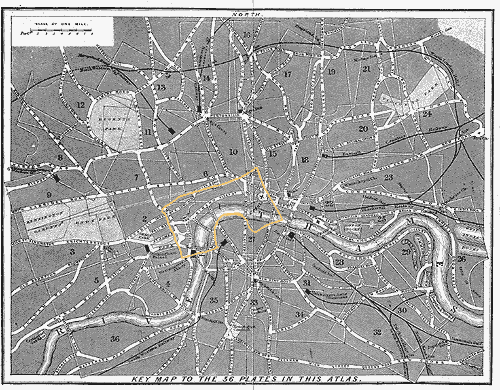
The Key Map of Collins' Atlas, showing
London as a whole, gives a useful overview of the locations mentioned
in this issue. Most of the locations described appear in the area
designated by numeral 1 on the Key Map, shown in detail on
Plate 1. All of the maps reproduced here have been highlighted for
convenience of reference and increased legibility.
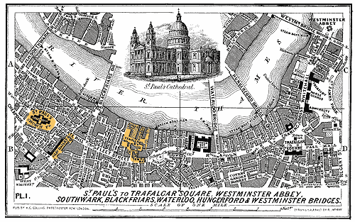
Pip and Herbert have moved out of Barnard's Inn
and have taken up residence in the Temple, living in "Gardencourt,
down by the river" (Ch. 39). The Temple, a complex of buildings
between Temple Bar and the Thames, is visible on Plate 1 of Collins'
Atlas (below), near the middle. As indicated previously, Hungerford
Bridge, which appears on this Plate, would not have existed in Pip's
time; but St. Paul's Cathedral -- which Pip can hear chiming the
hour from his residence -- is illustrated at the top of the Plate.
The Temple was originally named after the Knights
Templars -- a semi-martial, semi-religious body established in England
in the 12th century. By the 19th century, however, it had become
associated with the law, and housed law students and legal practitioners
(though it accepted occupants of other professions); it was composed
of both private residences and offices (Tallis's Illustrated
London, vol. 1, 44-8). Although Pip's Temple would have been
slightly different than the Temple represented on Collins' Atlas
and in Tallis's Illustrated London (even Pip notes that
alterations have been made to the Temple since he lived there),
many of the buildings were erected very early in the history of
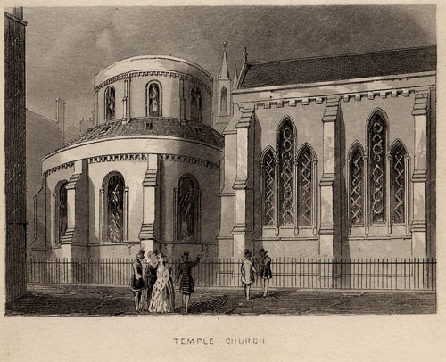
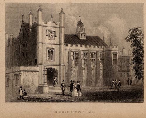
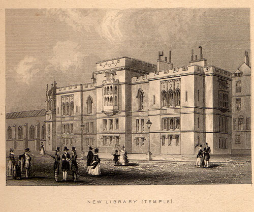
the Temple, and would have been familiar to him. Tallis's illustrates
(see below) Temple Church, a round Norman church dating from 1185;
Middle Temple Hall, which had been in place since the 16th century;
and the New Library, which, rebuilt in 1824, would have been relatively
new during Pip's tenure (circa 1828).
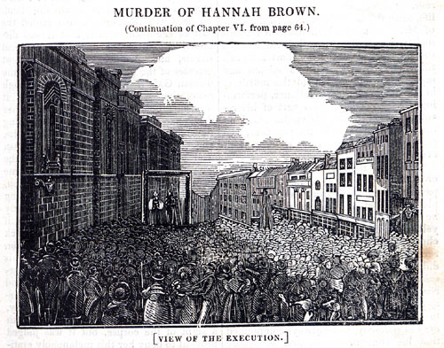
Pip, contemplating his convict-benefactor, thinks that Magwitch
is liable at any moment to be "hanged at the Old Bailey door" (Ch.
39). Executions were indeed held in front of the Old Bailey. The
illustration below, from a June 1837 issue of Martin's Annals
of Crime, shows a public hanging outside the Old Bailey. The
Old Bailey is also visible on Plate 1 of Collins' Atlas (see
Plate 1 again above), located between the Temple and St. Paul's
Churchyard. Pip was not far, living in the Temple, from the Old
Bailey door.
In the Eastern story: The Eastern story
to which Pip likens his experience is from Sir Charles Morell's
Tales of Genii, a book Dickens had as a child (Mitchell 501).
Assembly ball: An assembly ball is a "dance held by
subscription" (Mitchell 501).
Hired-out shepherd in a solitary hut:
Magwitch, transported for life to the Australian penal colony of
New South Wales, was "assigned" as a shepherd. According to the
1838 "Report from the Select Committee on Transportation," transported
convicts were subject to "assignment" -- a system of transferring
a convict from government to private supervision -- and put to work
according to the trade they had pursued when free in England. The
Select Committee classified convict-transports according to three
types -- servants, laborers, and mechanics (mechanics were convicts
with special skills, such as smiths, masons, carpenters, etc.).
The majority of transported convicts were laborers -- unskilled
-- and most of these, like Magwitch, were pressed into agricultural
work. The condition and experience of convicts varied according
to their assignments -- depending upon the clemency and liberality
of their masters, etc. Mechanics, being more useful than the average
convict laborer, were more sought-after, and generally treated better.
According to the Report of the Select Committee, however, "[t]he
condition ... of by far the most numerous class of convicts, those,
who [were] employed, as shepherds or neatherds, (of whom in 1837
there were above 8,000 in New South Wales), and in agriculture generally,
[was] undoubtedly inferior to that of a convict, who [was] either
a domestic servant or a mechanic; they [were], however, according
to most of the witnesses better fed, than the generality of agricultural
laborers in [England]; most masters either [paid] them wages in
money, or [gave] them, instead of money, tea, sugar, tobacco, spirits,
and other trifling indulgences" (606). This account agrees with
Magwitch's account of his experiences abroad.
Sent for life. It's death to come back:
Returning from transportation before one had served one's time was
prohibited on pain of death until 1834, though the last person actually
hanged for returning died in 1810 (Mitchell 502). Not all transported
convicts were sent, like Magwitch, on a life sentence, and all convicts
could, if they behaved well in the colonies, earn a kind of probation
-- a "ticket of leave" -- after a set interval. If a convict was
transported for seven years, a ticket of leave was obtainable after
four; if transported for 14 years, after six; and if transported
for life, after eight ("Report of the Select Committee" 612). A
ticket of leave allowed a convict, "according to certain regulations,
to work of his own account" ("Report" 612). Convicts could often
become quite prosperous and respectable upon receiving a ticket
of leave, as they were often preferred to other laborers for their
experience, and were sometimes allowed to advance to positions of
civic responsibility. According to the Select Committee, convicts
did occasionally become quite wealthy, typically by exploiting the
weaknesses and reduced means of other convicts -- lending sums at
interest, running public houses, accumulating property at interest
and default, etc. (613-4).
Bibliographical information
|

