|

NOTES ON THE NOVEL: ISSUE 14
Printable View
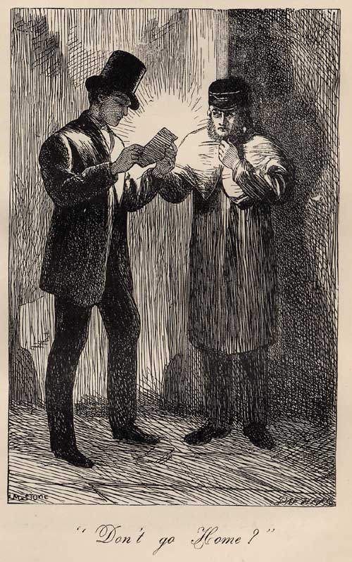
This illustration, by Marcus Stone, appeared
in the 1862 edition of Great Expectations. The original serial
(1860-1) and the 1861 editions of the novel were not illustrated.
A Note on the Maps:
William Smith's 1815 Map and Delineation of
the Strata of England and Wales with Part of Scotland gives
a detailed account of the geography and geology of most of Great
Britain. It consists of several large maps, each about 16x24 inches,
mounted on canvas. These maps can be folded into smaller squares,
and some of the seams -- where the map folds and the canvas shows
through -- are visible on the sections of the maps reproduced here.
The whole work consists of 16 large maps (a General Map of
England, Wales and Scotland, and 15 regional maps), together with
a Memoir discussing the geological study they illustrate.
Detail from Map 12, in a reduced size, is reproduced below.
The city maps used to illustrate this issue are
reproduced from Collins' Illustrated Atlas of London, published
in 1854. Pip's London would have been that of the 1820s, and Dickens'
London, at the time he was composing the novel, was that of 1860-1.
Collins' maps thus represent a London that falls between the historical
moment represented in the novel and the historical moment of the
novel's composition.
Since the chapters in this issue (Chs. 43-46)
take place in 1829 (Meckier 160), the maps from Collins' Atlas
used here show a city that has undergone about 25 years of change
since Pip's time. Nevertheless, they are very useful in tracking
Pip's progress through the city; the reader should merely keep in
mind that some of the landmarks would not have existed in the late
1820s. The most significant of these are the railway lines marked
on the Key Map -- the railroad did not enter London until
the late 1830s and early 1840s (Tallis's Illustrated London 186-7).
The Key Map also shows a bridge that Pip would not have recognized
-- the Hungerford Bridge between Waterloo and Westminster Bridges.
And London Bridge was, in Pip's time, Old London Bridge -- a different
structure, but built in essentially the same place. (New London
Bridge would have begun construction a few yards from Old London
Bridge when Pip was living in London, but would not have replaced
the old bridge during his tenure [Meckier 162]. Given that both
London Bridges would have been mapped in the same place, the difference
between the bridges makes no difference to our reading of the map.)
Any further discrepancies will be noted where appropriate.
History and features of Collins' Atlas
(1854)
Collins' Atlas was created in response
to the amplified tourist trade in London resulting from the Great
Exhibition of 1851. Previous to the Atlas, maps tended to
be very large and unwieldy, and though large city maps could be
folded up and carried, Collins designed his maps with a specific
view to portability (Dyos 10). The Atlas consists of one
large map of the whole city of London (the Key Map), followed
by 36 plates. The Key Map is drawn with numbered sections,
and these sections are represented in detail by the plates (the
numbers on the Key Map refer to the numbers of the plates).
The chief drawback to the Atlas is that, although the Key
Map keeps North at the top, the plates do not always observe
this convention (Dyos 13). This disregard of the compass, however
puzzling to someone attempting to navigate London in 1854, is in
many respects an advantage for the modern reader: The detailed plates
-- drawn to represent popular views of the city and/or popular routes
through it -- give us a unique view of the sites of Pip's adventures
in 19th century London. Any major discrepancies between the landmarks
shown on the maps and those that Pip would have been acquainted
with (given that the map was composed in 1854, about thirty years
after Pip's tenure in London) will be indicated where appropriate.
A tour of chapters 43-46
In Chapter 43, Pip follows Estella to Rochester.
He encounters Drummle, who has become a rival for Estella's affections,
at the Blue Boar, and they dispute the quality of their respective
home counties. These counties, together with a geographical analysis,
are shown on the map below.
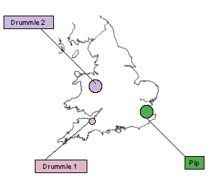
PIP AND DRUMMLE: A COMPARATIVE MAP
When Pip and Bentley Drummle meet at the Blue
Boar in Chapter 43, they antagonize one another by comparing their
home regions. Drummle pronounces Kent "beastly," and Pip replies,
"I am told it is rather like your Shropshire." The counties are
more opposite than alike: Shropshire (see "Drummle 2") is northwestern,
and Kent is southeastern; Shropshire is landlocked, and Kent is
on the sea.
It is interesting to note that there is a small
discrepancy in the text concerning Drummle's home county. Dickens
originally (Ch. 23) locates his parentage in Somerset (see "Drummle
1"); and though this location is opposite to Kent to the extent
that it is on the opposite side of England, and on roughly the opposite
inlet, it is arguable that Shropshire is more perfectly opposed.
Ultimately, Dickens seems to have preferred Shropshire to Somerset
(not only does Drummle apparently confirm it in his conversation
with Pip at the Blue Boar, but, in the original ending of the novel,
it is mentioned that Drummle has settled in Shropshire, suggesting
a return to his family seat). In either case, the geography seems
intended to suggest opposition.
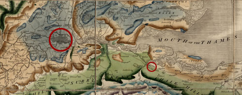
When Pip, in Chapter 44, walks all the way back
to London from Miss Havisham's (in Rochester), he covers a distance
of about 30 miles (Bagshaw, "Table"). A section of Smith's 1815
Map and Delineation of the Strata of England [etc.] (below)
shows these two cities relative to one another. The larger circle
(added to increase legibility) encloses London, and the smaller
encloses Rochester.
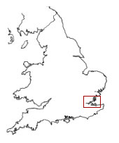
This drawing of England (below) indicates the portion of the country
illustrated by Smith's 1815 Strata map.
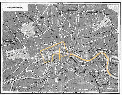
The Key Map of Collins' Atlas, showing
London as a whole, gives a useful overview of the locations mentioned
in this issue. Most of the locations described in Chapters 43-46
are located on the Key Map in area 1, and shown in detail
on the corresponding Plate. All of the maps reproduced here have
been highlighted for convenience of reference and increased legibility.
On the Key Map below, the area corresponding to Plate 1 has
been highlighted, as well as two bridges across the Thames (from
left to right, these are, respectively, Blackfriars and London Bridges),
and, stretching east of London Bridge, the "Pool."
When Pip returns to London, having walked all
the way from Rochester, "It was past midnight when [he] crossed
London Bridge. Pursuing the narrow intricacies of the streets which
at that time tended westward near the Middlesex shore of the river,
[his] readiest access to the Temple was close by the river-side,
through Whitefriars" (Ch. 44). Although the "intricacies" of the
streets in this area of London would have changed somewhat between
1829 (when Pip walks into town) and 1854 (when Collins' Atlas
was created), it is possible to trace Pip's return home on Plate
1 of the Atlas (below). London Bridge would be just off the
Plate (though visible on the Key Map above), to the left
of Southwark Bridge (which appears in the upper left corner). The
Middlesex side of the river is the side on which the Temple lies
(Middlesex is the county name). Whitefriars is visible to the left
of the Temple complex. As indicated previously, Hungerford Bridge,
which appears on this Plate, would not have existed during Pip's
time in London.
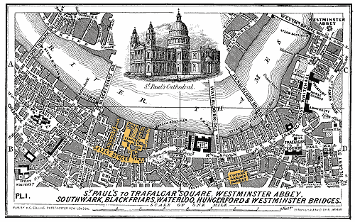
Receiving Wemmick's note ("Don't Go Home" [Ch. 44]), Pip turns out
of the Temple onto Fleet Street -- Fleet Street is visible on Plate
1, below the Temple and intersecting with Whitefriars -- and takes
a hackney-cab to the Hummums in Covent Garden. Covent Garden is
visible at the lower right of Plate 1. The Hummums -- the name derives
from the Persian word humoun, meaning "Turkish bath"
or "sweating" -- was, until 1865, a hotel on the southeast
side of Covent Garden (Mitchell 504). Due to the unconventional
orientation of this Plate, the southeast side is to the left of
the square that marks Covent Garden Market.
Herbert hides Magwitch down the Thames at "Mill
Pond Bank, Chink's Basin" (Ch. 46), which Pip is able to find by
"no other guide than the Old Green Copper Ropewalk." Given that
this Ropewalk is completely fictitious (unlike most of the other
landmarks in the novel), Magwitch is hidden, not only from the law,
but, to some extent, from the reader as well. We know, however,
that Magwitch is "down the Pool ... between Limehouse and Greenwich"
(45). The "Pool" refers to the Port of London, which extends from
London Bridge east to Deptford (Deptford is across the river from
Limehouse) (Tallis's Illustrated London, vol. 2, 153). The
full length of the Pool is visible on the Key Map of Collins
Atlas (see above), from London Bridge to Limehouse (Limehouse
is located at the far right). Given that Magwitch is somewhere between
Limehouse and Greenwich, however, his hiding place is beyond the
bounds of the Atlas.
Pip begins to row up and down the Thames, "at
first [keeping] above Blackfriar's Bridge" (in London proper --
visible on the Key Map and Plate 1), then moving as the tide
changes beyond Old London Bridge (also on the Key Map), and
"so [beginning] to row about among the shipping in the Pool, and
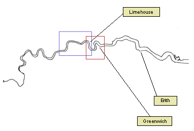
down to Erith" (Ch. 47). The location of Erith is shown, relative
to the location of Magwitch's hiding place (between Limehouse and
Greenwich), on the map below.
The blue box in the center of the map below marks
the area covered by the Key Map of Collins' Illustrated
Atlas of London. The red box to the right of center marks the
area -- "down the Pool there between Limehouse and Greenwich" (Ch.
45) -- where Magwitch is hidden.
The robber in the story-book: When Pip,
looking at Drummle as they stand before the fire at the Blue Boar,
feels "inclined to take him in [his] arms (as the robber in the
story-book is said to have taken the old lady), and seat him on
the fire" (Ch. 43), he is invoking one of the exploits of the outlaw
Dick Turpin, a popular subject of sensational writing in the 19th
century (Mitchell 503).
Argus: The pattern that the rush-light
(set in a perforated metal holder) casts upon the wall reminds Pip
of the hundred-eyed Argus of Greek mythology. After Argus' death,
Hera is said to have transferred his eyes to the peacock (OED,
"Argus").
The death of Captain Cook: Mrs. Whimple,
who keeps the house where the Barleys board, and where Magwitch
is hidden, has a copy of a "colored [engraving] on the wall, representing
the death of Captain Cook" (Ch. 46). This engraving, based on a
drawing by John Webber, was created by Francesco Bartolozzi and
William Byrne in 1784, and shows the death of Cook -- an 18th century
English navigator who was murdered by natives of Hawaii in 1779.
The engraving, and a more detailed account of Cook's experiences,
can be viewed at the UCLA Special Collections Website, http://www.library.ucla.edu/libraries/special/scweb/cookcheck7.htm
Double Gloucester: This English cheese
-- apparently of some dimensions, since Barley "can't expect to
get through [it] without hurting himself" (Ch. 46) -- is named for
the county, Gloucester, where it is produced (OED, "Gloucester").
Gout: Old Barley has a painful condition,
aggravated by the diet (of which rum and pepper form prominent parts)
on which he insists. According to the Oxford English Dictionary,
the word "gout" comes from words meaning "drop," because "[t]he
name is derived from the notion of the 'dropping' of a morbid material
from the blood in and around the joints." Gout is a disease which,
though primarily afflicting the joints, can spread to inner organs.
The inflammation of gout results from the accumulation of sodium
urate -- salts of uric acid -- around the joints, and often occurs
in the big toe, making it difficult or impossible to walk. The Dictionary
of Daily Wants (1858-9) suggests the following Victorian course
of treatment:
The
affected part is to be enveloped in soft wool or flannel, and
the patient's mind soothed; the limb kept at perfect rest, [and]
all exciting aliment discontinued.... When the joint will bear
friction, the flesh-brush should be used daily, a milk and vegetable
diet pursued, exercise and change of air adopted, and, where possible,
the bath or chalybeate waters moderately taken. The gouty deposits,
or concretions formed in joints of persons afflicted with gout,
or chalk stones, as they are commonly called, consisting of an
insoluble urate of soda, can only be dissipated in one
way, by steady use of benzoic acid, which, in doses of one scruple
combined with two drachms of the carbonate of potass, is to be
taken dissolved in water every day an hour after breakfast and
dinner, and continued till the depositions are absorbed. (479)
Rush-light: Pip asks for a night-light
at the Hummums, and is brought "the good old constitutional rush-light
of those virtuous days -- an object like the ghost of a walking
cane, which instantly broke its back if it were touched, which nothing
ever could be lighted at, and which was placed in solitary confinement
at the bottom of a high tin tower" (Ch. 45). This kind of light
-- primitive in comparison to gas lighting, which had appeared in
1807, but was still not universally adopted by the time Pip visits
the Hummums in 1829 (Meckier 182) -- is a kind of tallow candle.
Walsh's Domestic Economy (1858) gives the following description:
Tallow
candles are of three kinds -- moulds, dips, and rushlights. Moulds
and dips have each a cotton wick, while the rushlight has one
of rush.... Rushlights are made in the same way as dips [which
are] made by dipping the wicks in ... melted tallow again and
again, until they have acquired sufficient size for the purpose
to which they are allotted; after each dipping, except the last,
the candle is drawn through a hole in a board so as to remove
all superfluous lumps, and reduce it to the intended shape. Tallow
for candles should be a mixture of beef and mutton suet, in the
proportion of one-third of the former to two of the latter, if
the kidney-fat or suet only is used, but if any subcutaneous fat
is mixed with it, more than half of mutton fat must not be employed,
or the smell will be exceedingly unpleasant. Tallow candles always
smell more or less disagreeable, and for this reason they are
not used, except from economical considerations; but as they give
a good light when regularly snuffed, they still maintain their
hold upon those who value this quality more than they dislike
the unpleasant smell, which is chiefly given out when actual combustion
ceases, and the fatty matters are passing off into the air without
suffering decomposition. There are, however, two great objections
to these candles, one being, that from the size of the wick it
is not all burnt to ash, and requires constant snuffing; the other,
the disagreeable smell after being put out. (125)
Tester: When Pip looks up "into the corners
of the tester above [his] bed" (Ch. 45) at the Hummums, he is looking
into a canopy.
Bibliographical
information
|

